![]()
Who Uses Us
Lawson Avery

Our core focus at Lawson Avery is to provide accurate and timely advice to enable our clients to make the best decisions. To do this we provide a large number of services.
Riggs-Zschokke

We are a Wairarapa based Commercial and Residential construction company established in 1934. Our impressive record of achievement within the New Zealand construction industry includes outstanding client service, design, project management, workmanship and integrity.
At Tomlinson & Carruthers we undertake a variety of projects. Please select a category for some recent examples.
Listed Projects:
- Craggy Range
- Pahaoa
- Glenburn Station
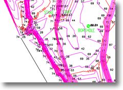
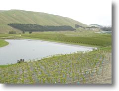
Craggy Range Winery
| Clients | Craggy Range Winery Limited |
| Job | Te Muna Road Vineyard, Martinborough |
| Short Description | Topographic Survey for Vineyard, Manager’s House, Winery and Dam Site, Vineyard Design and Set out. |
| Detail | The client required detailed levels around the area of the proposed winery and manager’s house for architectural and engineering design. Height information had to be correlated between these buildings on the higher terrace, and the dam and lower vineyard terrace for hydraulic drainage. New vineyard blocks had to be designed to match existing vine rows and site features, and set out when required.
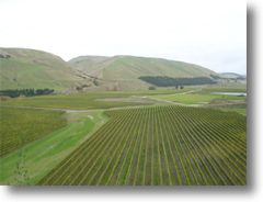
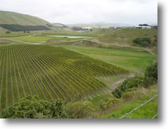
The scale of the site provided one challenge, being nearly 170 hectares. With several high terraces and sloping terrain, level control between sections of the vineyard required careful control. Setting out for new vine rows was done in the middle of winter, with the area experiencing some very sharp frosts. The equipment still works well in the cold, but the surveyors work marginally slower! Areas that required detailed site information were surveyed in terms of a known height datum, and in relation to the boundaries of the lots. All site features, fences and banks were fixed and related to aerial photographs. From this information, the area of new vineyard blocks could be calculated to fit the site and ensure the rows “flowed” from block to block. Topographic information was gained by EDM and GPS surveying. GPS made the transferring of heights very easy, and this was checked by EDM observations from each terrace level. Setting out of vine rows was also done by both methods. It was easy to sight through the EDM over a long distance to keep vine rows straight, while calculated row positions were quickly set out by EDM. On site adjustment of the rows was possible to fit new client requests. The topographic survey ensured that new buildings could be oriented correctly on site for maximum functionality. By fixing heights, the design of a future multi-floored winery building could be achieved, allowing for the most productive flow of the grapes and wine through the winery. The dam was constructed from our site plan, allowing water for frost control and irrigation. We helped the client maximise the area under production, and ensure that the look of the vineyard was right. Please click on the images below to the left to view a closer look. The images are large and will load in a separate window.
|
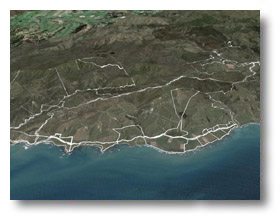
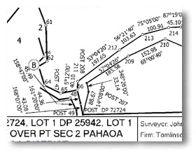
Pahaoa
| Clients | LA Poole |
| Job | Lifestyle hunting lodges, Pahaoa, Wairarapa Coast |
| Short Description | Planning, topographical survey and land survey of rural hunting lodge lifestyle subdivision. |
| Status | Construction |
| Detail |
Located on densely vegetated steep terrain, this 8 block hunting lodge lifestyle subdivision on the exposed south-eastern coast of the North Island required a variety of methods to accurately survey the 1800 hectares of the site. While most of the site was surveyed using GPS technology, some areas of thick vegetation in steep valleys required a combination of conventional methods with GPS technology.
|
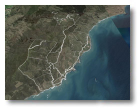
Glenburn Station
| Clients | Glenburn Station 2007 Limited |
| Job | Glenburn Station Subdivision |
| Short Description | Planning, topographical survey and land survey of coastal rural subdivision. |
| Status | Planning |
| Detail | When the owners of one of the oldest and largest stations in the country needed to reorganize their landholdings they looked for two things - local knowledge and efficiency. Tomlinson & Carruthers had a relationship of over 50 years surveying the coastal station and kept up with the times by using GPS.
The site itself is expansive and varied. Totalling over 6300 hectares the site includes coastal cliffs and dunes, river valleys and steep hill country. There is bush, forest and pasture throughout and sensitive flora and fauna sites along the coast. Planning will involve Tomlinson & Carruthers leading a team of specialists to achieve the most sustainable results. Surveying the existing coastline and access tracks will involve several teams of surveyors and technicians utilising GPS surveying equipment.
|